A Proposal for a TV Programme about the Holian Family
76 COUSINS, THE STORY OF AN IRISH MIGRANT FAMILY IN EARLY VICTORIA
ENVIRONMENTAL IMPACT OF EUROPEAN SETTLEMENT
IN NORTH EAST VICTORIA
The countryside in which the squatters settled in North East Victoria in the 1830s and 40s was very different to now. Today it is open farmland. Then the countryside was covered by dense forests of eucalypts and native pine and open grassed areas ranging from a hundred to several thousand acres. As they had done for millennia, the aborigines used their "fire-stick farming" methods to manage the land. There was extensive wildlife on the plains and in the rivers and creeks. The earlier settlers marveled at the lushness of the countryside teeming with wildlife. The soil was soft and fertile and the grass was yet to be trampled by flocks and herds.
In an authoritative survey of the topography, vegetation and wildlife of the broader region around St James - Devenish, "Natural Values of the Public Lands Along the Broken, Boosey and Nine Mile Creeks of Northeastern Victoria", Robinson & Mann (1996) record that in the 1870s farmers would blaze trees, or even plough a furrow through the forests to mark the route to avoid family members becoming lost. Local farmers were paid to guide travellers through thickly timbered country. In the mid-1870s at Lake Rohan, halfway on the surveyed road between Benalla and Yarrawonga, travellers would become "bushed" and lose their way. Town elders solved the problem using two horses and a plough to make a furrow from Lake Rowan to Yarrawonga (Willis, 1977) - a distance of some 30 km! In the 1880s, after the Kelly Outbreak, there were still black trackers in Benalla as there remained a likelihood of people being lost in the bush (Dunlop, 1975).
By 1840 squatters were arriving from Sydney driving their stock overland taking up squatting runs of thousands of acres. The squatter's way of life required little clearing of the land being able to graze their stock on the open expanses. However, the presence of Europeans had a disastrous impact on the native clans who succumbed to whiteman's diseases (mainly smallpox) and alcohol and their traditional way of life was disrupted. By the time selectors began arriving in the 1870s there were few aborigines left to be seen. A major environmental impact of the squatters was the resultant cessation of the aborigines' selective burning of the land.
Early settlers recorded that on the plains west of the Warby Range, wildlife was plentiful: kangaroos, emus, flocks of brolgas, wallabies, possums, koalas, wombats, big goannas, bandicoots and spotted cats. There were many types of bird including kookaburras, bustards, azure kingfishers and superb parrots. Although they didn't flow all the time, in the Broken River, Broken Creek and Boosey Creek there were Murray Cod, eel, freshwater crayfish, turtle, platypus, water rats and many types of waterbirds including ducks, ibis and cranes.
The bush is an enduring idea in Australia’s short history. In the new Victorian colony the idea took on substance at an early stage. For example in the following extract, Aunt Spencer tells of her journey by horse drawn vehicles in 1854 from Melbourne to the squatting run Bontharambo, on the Ovens River downstream of Wangaratta (Cooper, 1981).
We sometimes drive for twenty miles without seeing an individual. The country is open, more like English parks. … We cross a river by means of a punt which resembles a drawbridge. … As to roads, we are following only a track of footsteps; no fencing as boundary, except here and there. … I cannot describe the bush. It means ‘such’ an extent of country covered by trees. Some large, some small, no sign of human habitation except here and there a few camps or tents, some inhabited by blacks, who construct their huts by placing poles in position and covering them with the outer bark of the trees. … Indeed I durst not ride through the bush – not a human habitation near if taken ill. Through the bush the drivers are, to a great degree, guided by the sun – at night, by the moon or stars.
The situation changed with the arrival of the selectors. The Victorian Land Act of 1869 aimed at settlement of unoccupied areas and provided for individuals selecting allotments of up to 320 acres (half a square mile). A requirement of a selector's licence was clearing the block of its native vegetation allowing it to be used for crops and pasture. Selection of land in North East Victoria soon occurred and destruction of the natural landscape followed. The outcome was the open countryside we see today.
In their report, published in 1996, Robinson & Mann say: One hundred and twenty years later, only 1% of the former tree cover of these pine and box forests still survives in the eastern part of the Northern Plains and the woodlands found on the public estate along the Broken, Boosey and Nine Mile Creeks represent the largest remnant of this ecosystem in northern Victoria.
Referring to a pastoral station whose historic 1862 homestead is still located at Stewarton, 28 km north west of Benalla, Robinson & Mann observe the Emus have long since disappeared from the squatting run once named evocatively as ‘Emu Plains’, most of the orchids have not been recorded for many years and the wombats, honeysuckles, ‘stick nest rats’, ‘bandicoots’, ‘rat kangaroos’, Magpie Geese, spotted cats, bustards and quandongs have all become extinct in the eastern Northern Plains. Moreover, due to the large-scale clearing of the countryside and growth of introduced grasses and crops there are many once prolific species of plants and animals which are now endangered or threatened.
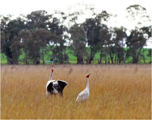
An ABC photo dated September 30, 2014 of a pair of brolgas at Moodie’s Swamp on the
Benalla-Tocumwal Road. It is thought there are only 60 brolgas left in Victoria.
With the widespread clearing of the natural vegetation and its use for cropping and grazing there are few remaining examples of what the original countryside looked like. They are restricted to a few State Parks which are not necessarily typical of the region. They remain, more or less intact, because they were undesirable areas for agriculture. Nevertheless, such reserves are important to conserve viable populations of woodland and grassland plants and animals. Major State Parks in the North East include:
WARBY-OVENS NATIONAL PARK
This is a large park with highly varying landscapes. It is characterised by three distinct vegetation communities - the granitic hills and woodlands of the Warby Range, the Box-Ironbark of the Killawarra Forest and the Redgum forest and wetlands of the unregulated Ovens Heritage River. In 1875, Ned Kelly worked at Dockendorff’s saw mill in the southern part of the Killawarra forest, The mill took ironbark and redgum logs, from between Mt Killawarra and the Ovens River, for railway sleepers and bridge timber for the Wangaratta–Beechworth branch line (Jones, 1995).
Information about the Warby-Ovens National Park can be found at:
http://parkweb.vic.gov.au/__data/assets/pdf_file/0020/315803/Park-note-Warby-Ovens-National-Park.pdf
REEF HILLS STATE PARK
Reef Hills State Park, south of Benalla, is a smaller park of forest and woodlands in low hilly country. In the Visitor Information it says The forest is an important remnant of the original vegetation of the northern plains of Victoria. Gold was discovered in 1860 and there was mining until the early 1900s. Timber was cut in the forest for mining and later for domestic firewood. Many old stumps, of a much larger girth than existing trees are evident. It is quite a contrast to leave the Park and cross the freeway on its northern edge and drive past big, old river redgums on the short distance into Benalla.
Information about the Reef Hills State Park can be found at:
http://parkweb.vic.gov.au/__data/assets/pdf_file/0009/315792/Park-note-Reef-Hills-State-Park.pdf
BROKEN-BOOSEY STATE PARK
The Broken-Boosey State Park is a linear park bordering the Broken, Nine Mile and Boosey Creeks. It is one of the few remaining remnants of high quality Grey Box Woodland on Victoria's northern plains, which have been largely cleared for agriculture. This is a much less formal park than compared to the previous two. It preserves the public land along the creek banks. There are a number of sites within the Park’s bounds in which there is much evidence of the original indigenous inhabitants and of the original flora and fauna. These include Rowan Swamp, Moodie Swamp, Tungamah Swamp, Muckatah Creek around Katamatite and elsewhere.
Information about the Broken-Boosey State Park can be found at:
http://parkweb.vic.gov.au/__data/assets/pdf_file/0010/314488/Park-note-Broken-Boosey-State-Park.pdf
REFERENCES
Doug Robinson & Sally Mann. Natural Values of the Public Lands Along the Broken, Boosey and Nine Mile Creeks of Northeastern Victoria. Shepparton 1996.
John Willis. St. James 1871 – 1977. St James 1977.
Alan Dunlop. Benalla Cavalcade, A History of Benalla. Melbourne 1975.
Amy Cooper (editor). Aunt Spencer’s Diary (1854). Geelong 1981.
Ian Jones. Ned Kelly [A Short Life]. Sydney 2008.